Friday, May 30, 2008

Another pretty picture

YOSEMITE NATIONAL PARK, CA - - We took a trip outside the park to Sonora on our days off, both to shop for more items we forgot/need and to 'escape' to real life. We found an Indian restaurant (Bombay Pizza...with a name like that no wonder we were the only customers.) visited another spot where we've had lunch before (good food, cash only) and blitzed the Wal-Mart.

The waterfalls and streams in the park are flowing strong after 5-6 days of intermittent rain. Come August everything will be a trickle...or less.

Thursday, May 29, 2008

Art shots


YOSEMITE NATIONAL PARK, CA - - Some times we have to let the inner artist come out. These are black and white shots

Monday, May 26, 2008

Cloudy, but no rain...yet

YOSEMITE NATIONAL PARK, CA - - Memorial Day Weekend, a time to enjoy the great outdoors. Thousands of folks created traffic jams getting into and around the park for three (fri., sat., sun.) days of on/off rain and 50's temperatures. Today, Memorial Day, looks a little brighter with low clouds and the threat of rain hanging in the air.

Two blogs down you'll see a pic from Glacier Point. Nobody is up there today or has been for the last three days. The road is closed due to snow. Half Dome has a snowy crown, but the low clouds don't let you really see it. Tioga Pass, the road to Nevada, opened Wednesday, and was closed by Friday morning. Plans to open a lot of the high country camp sites and services have been put off due to snow. Ah, the fun of working in Yosemite.

Our "tent among the boulders," isn't too bad. They have an evacuation-style plan instruction sheet on our door in clase of rock slide. The reality is if anything starts tumbling down the gigantic rock face right behind us the instructions won't help.

We've found out quickly that you really have to plan everything you do at least four or five steps ahead. Everything you need for the day or the trip or even a short walk/hike has to be packed, items put away in the bear box, and all unauthorized devices (extension cords) unplugged and put away. There's a system, a routine you need to get into to make life a bit easier.

Friday, May 23, 2008

We're still here

YOSEMITE NATIONAL PARK - - The 90-plus degree days have given way to 60-degree days which is nice. Internet connections are sparse. Paperwork continues to be a snafu here. The place remains spectacular despite the frustration.

Tuesday, May 20, 2008

Glacier Point perspective

YOSEMITE NATIONAL PARK, CA - - As part of our job training we got sent on a 4 hour tour to Glacier Point. Tough work, if you can get it. The Point overlook is a 7,200' and affords a special view. This photo included Half Dome (upper left); Nevada Fall which runs into Vernal Fall (lower right). The trail we hiked to Nevada went up the right side of Vernal Fall on the Mist Trail; crossed over by bridge and continued up the left side of Nevada to the top. From this perspective it looks like a 'little hike.'

You can hike to Glacier Point, which we did 4 years ago, on 4-Mile Trail....which is nearly five miles long...and gains 3,200' elevation from the valley floor. Of course, you have to hike back down also.

The day was a bit hazy without direct sunlight which makes the photo appear a bit 'flat' as you look out into the wilderness.

Sunday, May 18, 2008

Another one falls

YOSEMITE NATIONAL PARK - - The first of probably what will be many shots of Yosemite Fall(s) posted during our summer in the park. The water cascades over 2.000' on it's way to the bottom. The falls is the center piece of the park, photographed many times over by almost everone who stops in the park and can be seen from any number of places during a ride around the park loop.

As an added bonus for us, tonight we're watching a (free) showing of "Into the Wild" which was shot near Denali....and is the story of free spirit Chris McCandless and his ill fated trek into the wilds near the park. He died there.

Saturday, May 17, 2008

First 2008 Yosemite hike

YOSEMITE NATIONAL PARK, CA - - We hiked to the top of Nevada Falls on Saturday. Mist trail (above) gets its name from the swirling mist which drenches hikers, makes the natural rock steps/trail wet and slick and, when viewed from above, produces a nice rainbow. Four years ago we went down the trail...not the most fun thing to do.

The power of the water cascading over Nevada falls and rushing downstream only to take another powerful and beautiful pitch from Vernal Falls (which produces the mist for Mist Trail) never ceases amaze. The shot below, with a small rainbow, shows the power and turbulence in frothy display....a perfect reason why no swimming is allowed. FYI: More people are killed by drowning than anything else in Yosemite.

Friday, May 16, 2008

UPDATE

YOSEMITE NATIONAL PARK - - We're in the park slogging through the obstacle course of paperwork, housing and other mind-numbing, frustration-building items. Finding wi-fi isn't easy like we were told. No pics this time but the scenery is spectacular which somewhat makes up for the frustration factor.

Wednesday, May 14, 2008

Correction

MARIPOSA, CA - - The final item in my May 12 blog should have noted that Credence Clearwater Revival paid tribute to Buck Owens in their song "looking out my back door."

Mariposa (or butterfly in Spanish) is a gateway town for Yosemite. We're staying here tonight on our way into the park tomorrow. Somehow we seem to manage to hit areas where gold rush history is entwined in the location: Skagway (1898 Klondike Gold Rush); general area of Denali NP (early 1900's but nothing really came of the Kantishna location); Mariposa County (the trail of the 49ers (1849) with Hornitos being noted as one of the wildest towns in the Mother Lode).

Lizard Breath and other tales

FRESNO, CA - - Here's a fat little lizard whose photo I put up especially for the Queen back home. Since she seems to like our house sitter better than us, Queen may be sitting on his lap and reading this later on. We found this specimen sunning himself on our climb up Mono Rock in Sequoia National Park.

While we were driving around the park we stopped at an observation point looking into Kings Canyon NP. There was an information plaque showing various mountains which could be visible if there wasn't the heavy smog/haze in the distance. As we looked, a couple next to us started a conversation: "Where's Mt. McKinley, I know we can see it from here," she said. "Look at the map, it's somewhere near here." He shook his head and mumbled something. Lydia and I looked at each other, but said not a word. No sense in telling her that Denali (Mt.McKinley) was at least 2,000 miles north. And she probably wouldn't be happy if we told her she probably meant Mt. Whitney...which is the highest point in California and isn't visible from where we were.

Monday, May 12, 2008

Hazy Monday

BAKERSFIELD, CA - - We finally crossed over to the other side ... The Left Coast, The Land of Fruits and Nuts, La La Land, or just plain California. On our 480 mile trip from Zion National Park to Bakersfield we saw lots of high desert, the world's tallest thermometer (in Baker, CA, which interestingly goes up to 130-degrees) showing 88-degrees. What we really needed was an anemometer to gauge the wind speed as it varied from head wind to side wind and wobbled us around in Lil Blue the entire time.

So here we are in Bakersfield, home to plenty of farming / grape growing and oil operations. But that would be selling the town short if you are a fan of country music. The "Bakersfield Sound" changed the face of country music in about 1960 from slick Nashville production to a more natural sound from the most successful proponents Buck Owens and The Buckaroos and Merle Haggard and The Strangers. Texas born Owens moved to Bakersfield in 1950; died here in 2006 and his legacy lives on at Buck's Chrystal Palace.

FYI: The Beatles covered Owens' first big hit "Act Naturally" and Credence Clearwater Revival had a hit with Owens' song, "Looking out my back door."

Sunday, May 11, 2008

Angel's Landing, part 2

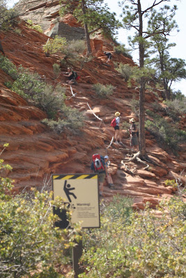
SPRINGDALE, UT - - PLEASE READ THE BLOG BELOW FIRST AS THIS IS PART #2....Anyway, when you pass the first set of chains you come to the lookout - - a stepping-off point for those with brave hearts and limber limbs making the final ascent. It's a rest area for others and known as "Chicken Out Point" as one look at the rest of the climb up to the top puts pause to those with thoughts of tall tales but no lack of fear to back up the point. I stayed at C.O.P. which has a fine sight line to the shuttle stop on the valley floor some 1,000' below. Lydia went on to the summit and is in the photo below ... a blue dot about midway in the pic. The shot captures only a small portion of the true climb. Maybe next time.

Angel's Landing, part 1

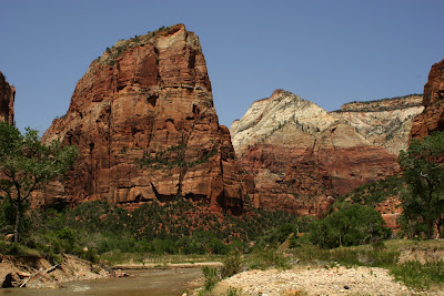
SPRINGDALE, UT - - This imposing sandstone monolith is Angel's Landing, one of the most talked about hikes in Zion. Only the brave need apply for the final push to the summit. The sign below is a warning to those afraid of heights and those not comfortable hanging onto chains to stop now. This is the easy part of the hard part and leads to Scouts Lookout. See part #2 of this blog.


How to tell you're getting old

SPRINGDALE, UT - - Yesterday, I officially got tagged as an old guy. It hurts to tell the story but...We got on one of the transfer buses in Zion after a rather hot hike. The bus was full. A twenty-something woman got up from her seat and told me to take it. I had a bruised ego and tired feet so I sat down. End of story

Saturday, May 10, 2008

Caught in the act

SPRINGDALE, UT - - It was a quiet morning on River Walk trail in Zion National Park...but evil lurks everywhere. As the surveilence photo (above) shows, there are a lot of beggars in certain national parks. Little furry guys and gals willing to do anything for a bite. Some are brazen like the fellow above, while others shamelessly pose and try to look cute like the suspect captured in the photo below.
We serched our database and came up with a photo of the The Grand Canyon variety of beggar (below). They are just as persistent. This one followed us for about 20 yards before assuming the attack posture.

Friday, May 09, 2008

Hiking info

CAMERON, AZ - - Bright Angel Trail descends at an average grade of 18-percent. The canyon rim trailhead is at 6860' elevation with the Three Mile Resthouse at 4748'. The canyon floor is at 2480. Hazards not mentioned in any information include mule droppings and large puddles/downhill streams of mule urine. So, when you're in a rhythm plugging along uphill and kicking up clouds of red dust - - and 16 mules have recently passed - - you also need to watch where you step. Murphy's Law #6860: If there's tricky footing or you aren't paying attention then that's where the mule crap will be.

Thursday, May 08, 2008

Mule Train

CAMERON, AZ - - There are options besides hiking into the canyon. You can ride a mule or, more to the point, hang on and hope the mule is relatively friendly. The group in this shot are returning from The Landing on Bright Angel Trail which is the far end of the trail you can see. On the short 12 mile ride for a mere $154 per person you can have your butt go numb and inherit a backache which will last all day within 30 minutes of heading out. Of course the brochure puts it much nicer. Oh, lunch is included. The long ride goes to Phantom Ranch at the bottom of the Canyon and costs a whole lot more. While the idea of riding seems interesting, you need to know that the mules like to ride close to the edge of the trail and, since the trail is way, way down and way, way back up you will either be trying not to become to intimate with the saddle horn on the trip down and then when the going turns up learn to be fast friends with the saddle horn as you need it to hang onto to keep from sliding off.

The building with the green roof in the picture is 3-Mile House where hikers stop for water and some shade. This is where Lydia and I turned around. It was also where we met two 20-ish guys who looked pretty beat. They said they'd been to Phantom Ranch. I wasn't paying too much attention when they said they had left the parking lot at 5:30am. This was 1pm and they had gone 21-miles. "We stayed at the bottom for half and hour," the apparent leader of the pack said. "Had a beer, waded in the Colorado River where it had pooled up and the cold wakes you up pretty quick. It was worth it, but our feet are trashed and we'll be dead tomorrow." So I ask you: who was crazier - - the folks who paid to get a butt ache or the guys trying to see how tough they were.

Wednesday, May 07, 2008

The view

CAMERON, AZ - - The Colorado River looks inviting from the South Rim of the Grand Canyon in this shot taken from the first view point inside the east gate to the NP. This is a new area for us as on past trips we have entered via the west gate north of Williams, AZ rather than this entrance which is accessed from highways north of Flagstaff. I was going to put up a 'toes over the edge' shot but then realized the shot didn't have the river in it.

Tuesday, May 06, 2008

Another long ribbon of blacktop and concrete

FLAGSTAFF, AZ - - Not too much in the way of photo opportunities today. We did see a couple of old churches, lots of red rock, a few passing freight trains, interstate exits that went basically nowhere, plenty of places to buy souviners, cheap gas ($3.31 per gallon) and prices ranging up to $3.67 per gallon. We hit the REI store in Albuquerque, NM, to buy a few things and got a lead on a good Mexican restaurant for lunch. Dinner tonight in Flagstaff was at a restaurant which served ..... Himalayan food which was somewhat like Indian cuisine. Tomorrow lots of photo ops unless the weather is bad as we head to the Grand Canyon...about a 110 mile drive from here.
Stay tuned.

Monday, May 05, 2008

Crop Duster update

SANTA ROSA, NM - - Thanks to a friend's information, I got a lead on the crop duster pictured in yesterday's blog. The plane in question is a 1978 Grumman G 164-B better known as the Grumman AgCat, a purpose-built agricultural biplane which began production in May of 1957.
This model AgCat is powered by a radial Pratt & Whitney R 1340 (9 cylinders) producing 600 horsepower. It has a constant speed, two blade prop. By Google-ing the tail number I found that the plane belongs to Foshee Dusting Co., Inc. of Natchitoches County, LA.
In other news, we're 600 miles farther down the road in Santa Rosa, New Mexico...600 interstate miles but the scenery is getting better.

Sunday, May 04, 2008

Flying low

SALLISAW, OK - - Before we got out of Mississippi this morning we spotted this aerial acrobat plying his trade of crop dusting in this special agricultural aircraft or top dresser. Double click on the photo above and you can see the pilot wasn't so busy trying not to plow the field instead of spraying it that he couldn't take a look at me. The second photo of the plane heading away is for detail. I Googled a number of sites but couldn't come up with any information on a bi-plane like this one.

Sallisaw got its name from a French word for salt deposits. Buffalo hunters in the late 1800s used salt bought here to preserve buffalo hides and other animal skins. This area belonged in turn to Spain, France, the Cherokee Indian Nation and the U.S. The Cherokee got the heave-ho, along with most of Florida's Seminole Nation and three other tribes in a relocation plan to move them to Oklahoma. That infamous forced march/relocation and the resulting inhumane treatment of those involved became known as "The Trail of Tears."

Saturday, May 03, 2008

GREETINGS

HATTIESBURG MS - - Greetings from The Days Inn in Hattiesburg, Mississippi. We're finally on the road; we're heading west and, right now, if it isn't Interstate travel it's some scenic marked route past cotton fields, peanut crops, sorghum and whatever else they grow out here. More tomorrow.