 MAMMOTH MOUNTAIN, CA - - After ourMonday hike to Sunrise Lake High Sierra Camp we took Tuesday off and went looking around on the Nevada side of Tioga Pass - - although we were still in CA. We did the June Lake Loop and then went to Mammoth Mountain, a very popular ski area in winter which looks like its been totally wasted in the day. The area is used for mountain bike trails and was doing a booming business. The toughest trails for the expert riders seem to drop off from the top (11,053') into space...as these two riders are about to do. The "Beginner" trail didn't have a high enough "chicken factor" for me to even contemplate. Any way, who wants to do a 'face plant' in an area where you could be skidding on your face for hundreds of yards?
SUMMER 2017: Back on the road again. SUMMER 2016: No travel. In health recovery mode. SUMMER 2015: Out West and house sitting SUMMER 2014: Out West SUMMER 2013: Back to Glacier NP; SUMMER 2012: Glacier NP; SUMMER 2011: Yellowstone and Glacier NP doubleheader; SUMMER 2010: Working on the Grand Canyon's North Rim; SUMMER 2009: June vacation in Nova Scotia; SUMMER 2008: Hiking in Yosemite National Park; SUMMER 2007: Alaska's Denali National Park; SUMMER 2006 :Gold Fever! in Skagway, AK
Thursday, July 31, 2008
Mammoth Mountain
 MAMMOTH MOUNTAIN, CA - - After ourMonday hike to Sunrise Lake High Sierra Camp we took Tuesday off and went looking around on the Nevada side of Tioga Pass - - although we were still in CA. We did the June Lake Loop and then went to Mammoth Mountain, a very popular ski area in winter which looks like its been totally wasted in the day. The area is used for mountain bike trails and was doing a booming business. The toughest trails for the expert riders seem to drop off from the top (11,053') into space...as these two riders are about to do. The "Beginner" trail didn't have a high enough "chicken factor" for me to even contemplate. Any way, who wants to do a 'face plant' in an area where you could be skidding on your face for hundreds of yards?
No Smoking
Saturday, July 26, 2008
Saddlebag Lakes
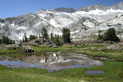
 JUST OUTSIDE YOSEMITE NATIONAL PARK, CA - - Our meandering hike around Saddlebag Lake surrounded us with scenery which made taking pictures easy...and there was always time for another whether of the shooter shooting a pic or a reflection of the snow in a small pond. See Lydia's blog for a more detailed story on our best days off yet.
Thursday, July 24, 2008
Train time
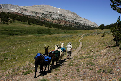
 YOSEMITE NATIONAL PARK, CA - - The spectacular scenery of our Mono Pass hike on 7/22 was highlighted by encounters with a pack train of mules supplying a camping site for scientists studying lizards in the High Country...and a couple hiking with 4 Llamas carrying their gear. The area where the pictures were taken is at 10,599' according to a survey marker we saw. This is the 'real' Yosemite unburdened by thousands of day-trippers.
Thursday, July 10, 2008
Valley views
 YOSEMITE NATIONAL PARK, CA - - LH was working Wednesday, so I hiked up to Glacier point. The Four Mile Trail - - which is 4.6 or 4.8 miles long depending on which trail signs/books you check - -climbs 3,200' to the top. I tacked on another 2.6 miles on a hike nearly to the top of Sentinel Dome (we ran out of time) with the driver of the Glacier Point Tour bus - - which I then rode back down to the trail head in the valley where I had parked our car.
About halfway up the trail it was easy to see the ever-depleting Yosemite Falls, the hallmark of the park. It's about 25 percent of what it was when we arrived. No more thunderous roar from the over 1,400'; first drop. The snow melt which feeds the falls is pretty well melted.
 Bridalveil Falls, on the other hand, is still flowing pretty well. It's on the north side of the valley and the snow melt process is slower. This is a fall (one continuous drop) as opposed to Yosemite Falls (three drops to the bottom).
 El Capitan, the rock climbers dream, is pretty quite these days. Other than a new record for speed climbing set a week ago at 2hrs, 43mins, 37secs. there isn't much activity. It's hot so in July and August when the temperatures are above 90 and the sun is on the wall most of the time the climbers wait. September brings cooler temps and they begin to climb in large numbers again. I could only spot two climbers from where I shot this pic and then only because they had on bright colors
Wednesday, July 02, 2008
Trail Guides
 YOSEMITE NATIONAL PARK, CA - - The Wellness Center had a poster up in the kitchen trailer advertising a hike to Kibbie Lake. We checked our Yosemite hiker's guide and the hike sounded interesting. Plus, it was their gas. Three hours of driving later, we reached the trailhead at the end of a single lane fire road. During the drive we quickly learned that the organizer had never been to the end of the road or on the trail. Fortunately, the trail was relatively easy to follow.....until we ran into a huge granite outcropping on our left, a stream on the right and no easily discernible trail. Enter the group above - - Father Steve, an elementary school principal, and sons Ben (red shorts) and Sam. Ben was my personal guide and told me he had carried his own pack to their camp, asked a lot of questions and was unfailingly polite.
They guided us up a barely visible trail through heavy growth bushes up to the granite face and onward to the 6,513' top near where they were camped. The lake stretched out ahead and beside us (below).
LH had explored the trail we finally took minutes earlier and signaled us to follow...and then took off with single-minded determination to find a route. She did, but to the other side of the lake. See Below.

Cold Water
 YOSEMITE NATIONAL PARK, CA - - Having discovered that by going off on her own that she had outsmarted herself, Faithful Scout contemplates a nice cold trip through a Kibbie Lake off-shoot to reach the side everyone else was one.
 While the water was nice and clear - - snowmelt usually is - - this explorer found it a bit deeper than planned. Help, in the form of Sam, is swimming in her direction to aid, if necessary, getting the backpack across. So, half soaked LH reached the side of the lake we were on and, a short while later, put on her bathing suit and went for a swim.

Subscribe to:
Posts (Atom)
